Not sure who runs the Dressage Hub group on Facebook, but they seem rather thrilled that it’s all starting to go wrong weather-wise. Seems very unsporting.
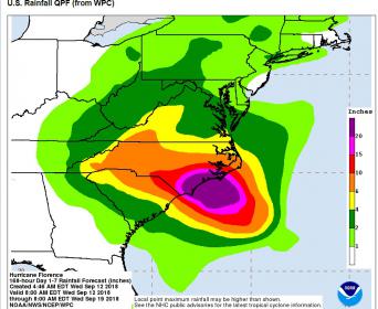
According to National Hurricane Center this morning, they are showing the storm following the NC/SC states line. The prediction for rain in the tryon area over the next five days is 5-10 inches with the possibility of 40-50 MPH winds on Saturday. Of course all that could change as hurricanes are unpredictable. When I went to bed last night the forecast for our area of VA was 12-18 inches of rain. Now it is down to 5-10.
As some models predicted, Flo is thinking she will stall at the coast and then slide south and cut up through SC.toward GA. “D” on that map is situated in the Anderson SC area, and indicates tropical depression status (0200 Monday).
But she will still be slinging a lot of rain and wind to the north a she moves through. New rainfall projections for TIEC area look to be in the 6-10" range. Bear in mind that is the predicted total through Wed 9/19. Depending on where she goes and how fast and if she decides to just sit somewhere for a while, a lot of that rain could come in a short period of time, or be spread out throughout the next week. At any rate, it is getting real for the folks at WEG. Prayers for all in Flo’s path.

I am looking for a refund through my insurance policy that I took out. Funny thing is, I never take out travel insurance. So glad I did for this trip! I do not expect WEG to refund my money. The reference to the credit card giving me a refund is through their trip insurance policy. I don’t know if they will cover it, but it is worth a shot!
Endurance is running today, so those horses will be done and possibly gone by the time anything shows up from this storm.
Unfortunately this morning the storm seemed to be turning a bit south and slowing down which poses a greater threat to the Tryon area. Everyone just keep sending positive vibes that way and hope for the best while preparing for the worst.
I don’t participate in Facebook so haven’t seen that. From what you say, it seems more than unsporting. It is disgusting to be “thrilled” that people and horses are in harms way.
Dressage Hub is a known troll I believe. Avoid at all costs.
Glad to hear endurance is early, but sad to hear they have screwed their start today.
they did say there are 2 important data centers near by - that implies they have considered power failures.
Some credit cards have trip cancellation protection if you paid for the whole trip on that CC (deposit and final payments). It is amazing what is in the small print with the CC inserts. Weather related and non-refundable are some of the conditions.
I can’t blame them really.
Water already today https://www.facebook.com/pisces.bobo/videos/pcb.10160859444410252/10160859418565252/
Especially as it was just the reserve
Clicking around in NOAA website is great. The storm CENTER is shown in the Tryon area on Sunday, but the tropical storm force winds arrive THURSDAY NIGHT, and then the rain starts, I believe. The conditions will worsen well before the center arrives. [ I was in Aiken SC for Hugo, and we had wind and rain for something like 6 HOURS before the center; it was a wild night, and the next day was BEAUTIFUL weather… ]
Anyway, am I misreading the NOAA maps?
[ I cannot figure out how to embed graphics… so here is a link about the arrival of winds] :
https://www.nhc.noaa.gov/refresh/graphics_at1+shtml/152637.shtml?mltoa34#contents
OH! Here is an interactive map!!!
https://www.nhc.noaa.gov/refresh/graphics_at1+shtml/152637.shtml?gm_track#contents
I’m afraid the statement below from WEG is off by a few days. And I saw a map with wind speeds of 40-60 mph, with gusts above that.
Wednesday, September 12, 3:45pm:
“Today’s update from the National Weather Service, stationed onsite at TIEC for the duration of WEG, shows that Hurricane Florence Is now expected to make landfall near the North and South Carolina coastal border on Friday evening. The projected weather pattern here at TIEC will be heavy rain on Sunday evening into Monday and possibly Tuesday, with winds peaking on Sunday evening at 30mph with gusts of up to 40mph.”
Hmmmm.
Yes, the NOAA NHS site is great.Graphics, satellite images, storm surge estimates that you can zoom in on right to where you live, too many cool thing to list.
When Florence comes closer to landfall there won’t be as much guesswork and the graphics will be easier to understand.
I hope The WEG is spared. They are off to a terrible start even without the hurricane.
On the Tryon NWC forecast, there is a discussion of what is likely to happen. One thing that surprised me is that most of the rainfall will come on the EAST side of the hurricane as she stalls in the mountains, so most of the rain will be Sunday and Monday. There is also a tornado possibility for that same period. “Conditions should improve by next Wednesday or Thursday”
Yes, the “upper right” [northeast] quadrant of hurricanes in this part of the world is always the most powerful.
Here is the latest rainfall prediction; https://www.nhc.noaa.gov/refresh/graphics_at1+shtml/212431.shtml?rainqpf#contents 4"-6" possibility of 6"-10". 
A sample of the NHS strorm surge map. You can zoom in on your area. Click on Continue, then “Imagery with Labels” in Upper right corner https://www.nhc.noaa.gov/refresh/gra…ation#contents
Yes, the northeast side is the worst, it’s called the ‘dirty side’ for a good reason. That’s the worst side for wind and rain. I live about 90 miles from the gulf coast, and the best house configuration is with the garage doors, and regular doors on the east and west side, because the circular pattern of wind and rain nails the north and south side the worst.
