Cross Country CD Chosen for LA Olympics

From Nearmap. The blue outline is the parcel’s boundaries.

Closeup:

I wonder if part of the track will go over the northern section screenshotted below. Looks like tracks & trees, and some spill into a parking lot with possible manure? I can’t tell. Never been to SA, but looks more manageable than I initially thought reading comments here first.

Another closeup taken - it looks like there’s already potentially work being done, because there are mounds of fill and trucks visible in the April 2025 flyover that weren’t there in earlier years. I took another screenshot of the northern section - this wooded area looks workable and is roughly 16 acres without including the section of the parking lot that’s covered in sand, which is another 19 acres. I’ve never been to SA, so I have no idea if this is planned to be used.


6 Likes

Hmm. Very interesting. Thanks for sharing.

Question for the locals–what is that “wooded” area highlighted in beowulf’s post being used for now? It looks like some kind of paths/trails are there.

Logistically, if you’re having to build, I’d think they’d put something that needed terrain/construction in that parking lot area, like a water complex. And then just have jumps on the turf track and those three existing infield rings, a la arena eventing. That would interfere with the racing meet the least, outside of whether it’s good for the sport.

That is the arboretum. The Los Angeles Arboretum and Botanic Gardens.

2 Likes

Ah, thanks for clearing that up. I had no idea. Well… the parking lot is still about 19 acres… :laughing:

I think the area @JenEM is referring to is to the north of the parking lot within the blue boundary. It is fairly open, and there appear to be trees and paths and a few structures.

It appears the Arboretum is more to the west of the race track and across a big, presumably busy street.

In looking at the imagery of the potential area as highlighted by @beowulf, I am struck by how many different surfaces might be used - infield, race track, turf track, converted parking lot, dirt. Am I remembering correctly that studies have shown that changing surfaces can contribute significantly to injuries on xc?

ETA snip from Google maps that clearly shows arboretum:

2 Likes

When you zoom in on the area to north on google earth, it appears to be some kind of maintenance facility. That’s why all the trucks are there. Zooming in I see a lot of horse trailers parked in there as well. Looking through the rest of it, I see various maintenance type buildings. It is certainly not a park.

The area where it looks like sand has been trucked in is a lot of piles of some kind of earth. It looks like it has been there for quite a while. I wonder if this is materials for maintaining the track.

The long green stretch that sort of looks like a sideways “?” Is the El Camino Real chute. It enables SA to run the one and 3/4 mile San Capistrano, one of the longest TB races now run in the U.S. So there is quite a bit of land. How to use it is something else.

3 Likes

That’s interesting. Is it run on the grass the whole way?

I’m wondering how they could lay out a cross country course with enough jumps that would not involve so many twists and turns that nobody could even remember it, no matter how many times they walk the course.

Yes, down the chute, which has a right hand bend, very unusual on U.S. tracks. Then across the main (dirt) SA track, then to the turf course, then once around the turf course to the finish. The horses don’t seem to mind the grass/dirt/grass bit when they cross the main track.

1 Like

There is a reason they no longer use the “turf chute” at Santa Anita, and it is exactly what you say. The change in surfaces caused quite a few horse deaths and one or two jockey deaths when the horse went down.

@Maythehorsebewithme, see above. It was part of why the state of California became involved with Santa Anita. I believe 19 horses died in one year? One reason was that sudden change in footing and even with multiple changes of the dirt track, they couldn’t stop.

As a jockey friend said, “Belinda is out to destroy 2 horse sports now that she destroyed racing.”

2 Likes

The state of California has required Santa Anita to address all of the horse deaths on the track over the years and even as of 2023, they had to change the track footing again back to sand as horses were still breaking down on the synthetic.

1 Like

19 acres is just not enough to put up a XC course. Where is the “country” part?

2 Likes

See below. Chute still used, has been redone. The horse deaths circa 2019/2020 were terrible, but there were more on the dirt than on turf. I don’t think they ever figured out exactly why, but some thought it was due to extraordinarily heavy rain and/or extraordinarily heavy use of drugs.
https://paulickreport.com/news/the-biz/santa-anita-turf-course-undergoes-annual-renovation

3 Likes

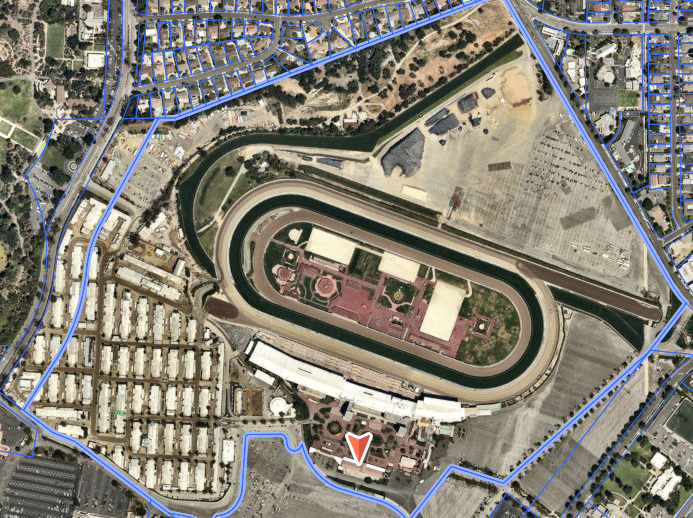
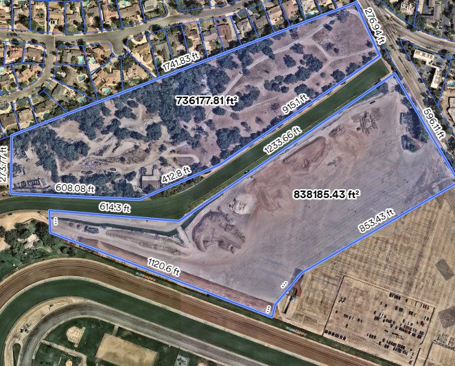
I’m gonna jump in here for a sec. For relevance I lived in LA (Burbank, for actual location) in '97 - late '00. I used to work as an exercise rider for Richard Mandella and galloped at Santa Anita. Now, it WAS 25 years ago. That said, that area has only changed slightly due to the firm boundaries and lack of expansion given the terrain (Mountains you can’t build into not that far away) and the properties that exist against the boundaries. (Arboretum, Botanical Gardens, Shopping Center, Hospital, etc)

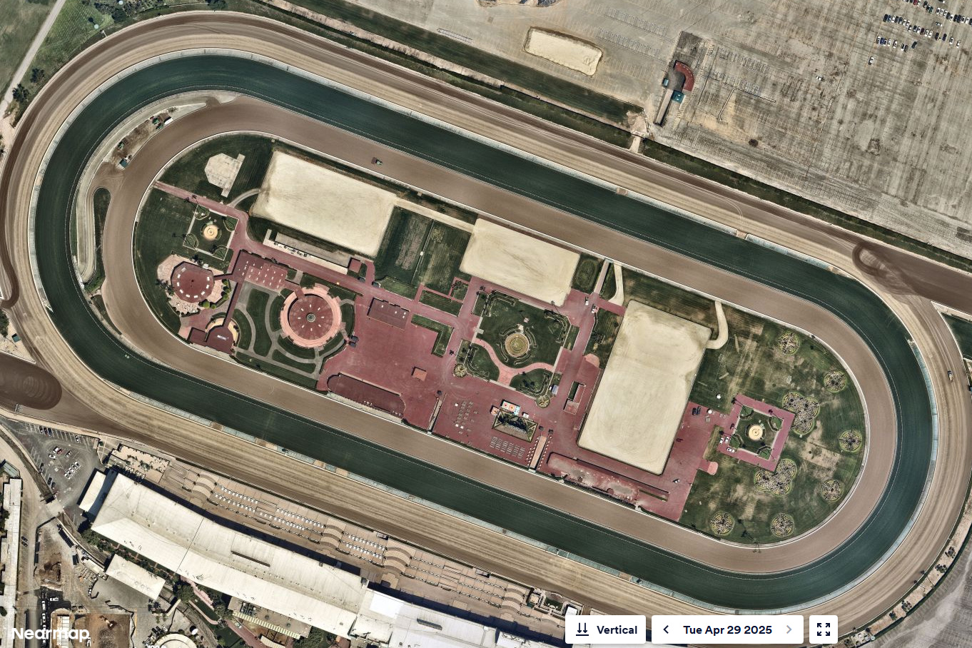
So fwiw, they added 3 rings into the infield (Seen in one of the pics above) to add shows into the “fun.” A friend of mine got to be the course designer for some jumper shows held there. There’s some thought this should have been a shot across the bow that the Stronach’s were up to something.

This 17 minute video can show you what the track and surrounding areas look like.

https://www.youtube.com/watch?v=UaK5O0pbCyA

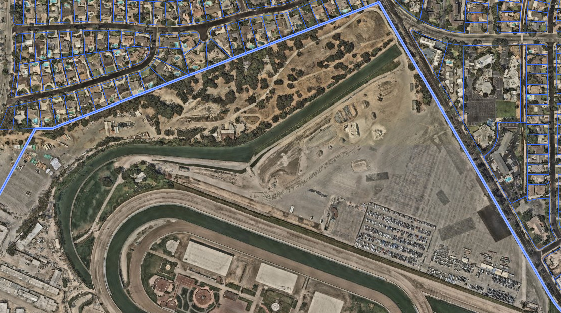
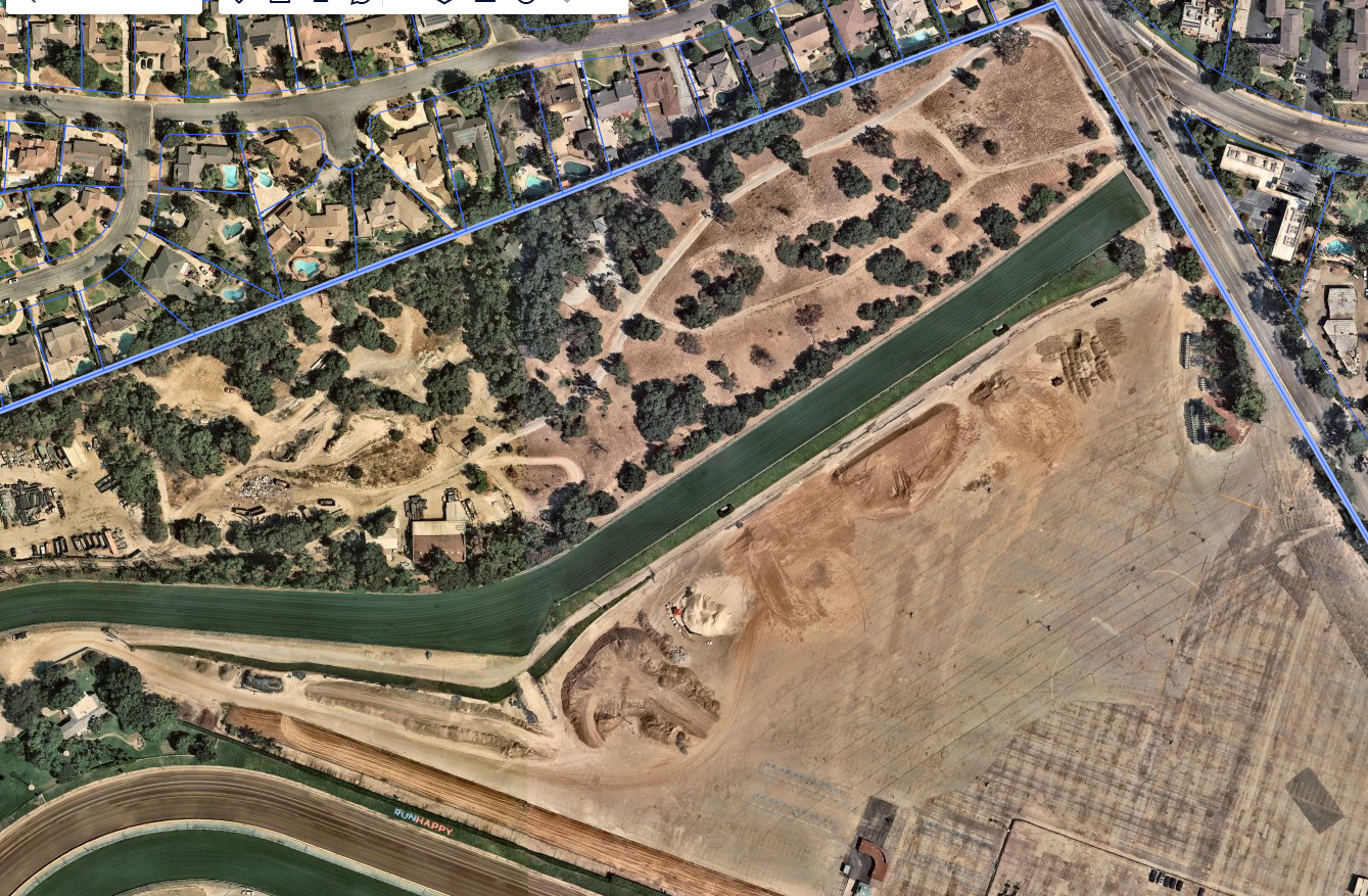
At minute marker 3:08 - 3:18 you can see there is NO terrain. The turf hill would be tough it you went up it and it was novice level. Otherwise…0 natural terrain. The chute is around 1/2 mile long.

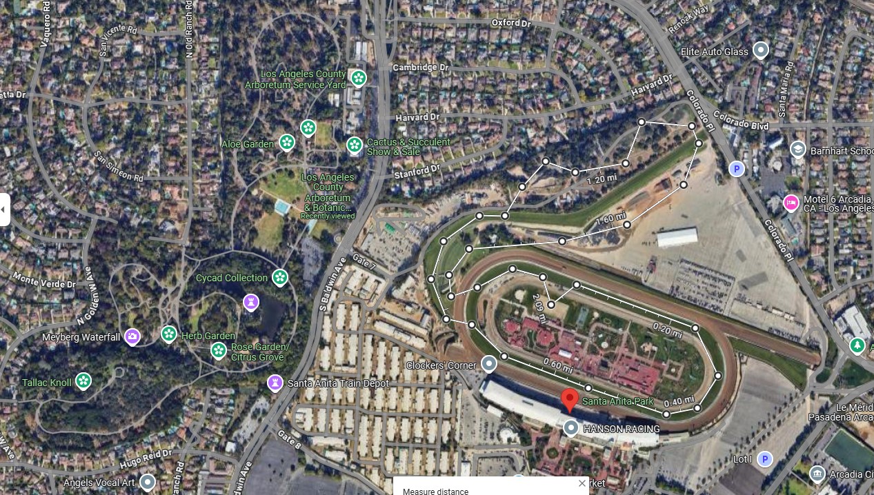
From an article about the Downhill turf course reopening in 2021:

“Despite the optics being a big drop in elevation the difference between the top of the course and the finish line is only 29 feet.”

You can see a turf race video here that shows how it bends down to the main track.

https://www.youtube.com/watch?v=hAm9KbgYCmE

View from Google Street View of the far end of the property across from the grandstand. Against the parking lots that exist against Huntington Dr.

View From the “Shops at Santa Anita” parking lot looking at the Main gates. (This pic is from 2018, the stores do exist now)

View from the “top” of the turf chute:

I am giving you all the tools to make your own thoughts. But I think we can agree this is FAR worse than what we each thought was the 'worst" Olympics course prior to this point. Whatever the year you believe was in that category.

Emily

23 Likes

And this is the USA Olympics.

Remembering the XC courses of the London Olympics, the Rio Olympics … this will not be the quality of one of those. Hopefully it will be remembered better than, say, Hong Kong?

1 Like

My question is where they’ll put a water complex. To do so, they’d probably have to dig a couple sections of somewhere up as a decent 4*-S track would have at least 2. Or one really big one split into 2.

2 Likes

The farm I boarded at forever is 25 acres and I can’t imagine a local schooling HT there let alone an Olympics. Yikes.

Making a fat profit while offloading Santa Anita in the process.

Every day my hatred of them grows a little larger.

7 Likes

This Olympics won’t be anything like the 1984 with its roads and tracks, etc. This will be arena eventing. They’ll add lots of foliage to make it pretty and… Bob’s your uncle.

2 Likes